Conflict archaeology of the German Occupation is everywhere you look around the Channel Islands. Some of us have it in our homes and gardens!
I live right next to the coast on the south of the Island. All around the coast there are examples of conflict archaeology and reminders of both English/British military fortifications (from the period from the early 13th century to mid 19th century) and the German Occupation 1940 to 1945.
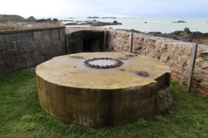
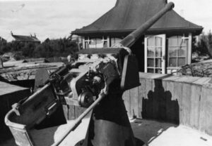
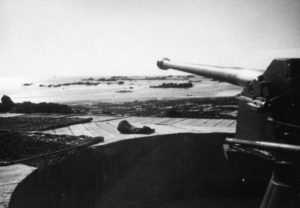
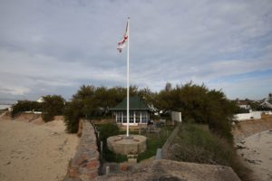
Our house is a newish house built (with others) on the site of an older and larger and grander house which was demolished to make way for the new builds about 15 years ago. When we moved, I was aware that at the bottom of the garden, immediately adjacent to the sea wall, a German gun emplacement existed together with a Torbruk emplacement (classified as a Resistance Point and part of a larger Strongpoint with other positions). The emplacement base had been completely hidden by previous owners by a very large (and not particularly attractive) rockery and other than the fact that you could see the entrance to the Torbuk emplacement in the back of the sea wall (the open top of the position had also been concreted over) many people would have not even been aware it was there.
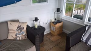
Standing behind the emplacement is a summer house, which looked to me as if it was from the between the wars era, whereas others said that it could not possibly be that early in light of the fact that the Germans had fortified the position and a beach house wouldn’t have been there during the Occupation.
Before we moved into the house, we had a certain amount of work done to the house and garden. It was during that work that we made a number of surprising discoveries which have given us a greater insight about what happened here in this very small area, and which is perhaps indicative of the wider picture.
In the garden, we removed the rockery to expose the base of the gun emplacement, principally because it created a lot more space and we thought that the base might prove to be a platform which might have some decking and cushions to make a seat for lounging! As it has turned out, we now have another re-purposed use which is evident in the photo at the end of this post!
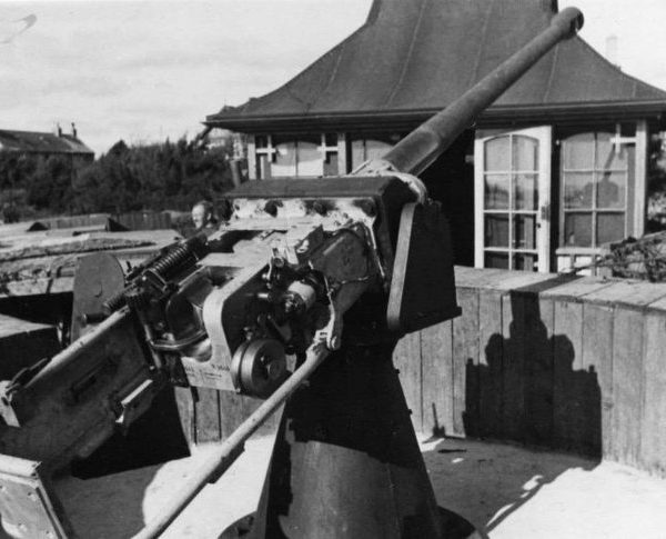
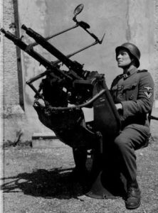
In the course of renovating the summer house, we laid an electrical cable to it and when digging the trench across the lawn, the workmen phoned me at work to say that they had “hit” a large concrete structure under the lawn! Upon further investigation, it turned out to be a concrete 2 man personal shelter which had been completely buried under the lawn at some time since the Occupation. Inside we found the base of an anti-aircraft gun mounting and seat (unfortunately no guns!) which appeared to have been dumped in there – I have mislaid the photos I took at the time, but here is what the whole thing would have looked like.
Also inside were some old empty champagne bottles and the remains of an old broken cast iron stove. The labels on the bottles indicated that the champagne was a 1937 pre-war vintage. At this stage the existence of the broken stove fragments were somewhat of a mystery but we found out their origins later.
Rather than fully excavate and clean out the shelter (there is a certain amount of rubble on the floor, but nothing visibly interesting), we have covered over the entrances and reburied it under the lawn (perhaps to be reopened again at a later date). The base of the anti-aircraft gun mounting went to a collector and it was him who told me that he had seen some period photos showing the gun emplacement and the summerhouse in the background.
He then proceeded to look at the summerhouse a little more closely and we found graffiti which appears to be from the Occupation, and which proves that not only was the summerhouse pre-war, but also it was used by soldiers of the occupying forces who were posted to this particular Resistance Nest.
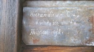
The rather moving inscription above is translated – “Here at this place, I often think of home”. (The lead has been whitened and the photo has been slightly retouched to make the lettering clearer to view)
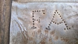
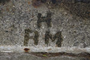
Outside we also found lettering impressed into concrete as well as discovering empty bullet cases, remnants of barb wire and barb wire posts.
And inside the summerhouse, as we were cleaning the floor, we found the burn marks from hot coals and realised that the summerhouse had been modified to house the stove and the flue for it had been routed through the wall where an opening had been cut, and which now was a small, but oddly placed, glazed window.
So looking at this conflict archaeology, this is my interpretation of a timeline since 1940:
– a large house on a prominent coastal position was taken over by the occupying forces in 1940
– They utilise existing structures (the summerhouse and presumably the main house). The building existed before and outwardly, any enemy looking at them would hopefully see only them (unfortified) rather the German camouflaged positions. The main house might have been used as a billet? The Germans also utilised the summerhouse as a very practical and heated shelter for the troops who no doubt had to stand guard on cold winter days and nights.
the forces posted here are demonstrating that they are here to stay by a building the emplacement ,the protective shelter immediately behind the summerhouse and other physical evidence that they left.
– The lettering impressions in the concrete and the initials and date graffiti suggests a claim of “ownership” to the place?
– The champagne bottles are interesting. Were they in the Island and “requisitioned” by the occupying forces? When did this happen? May be it was later in the Occupation, and was “liberated” and drunk by troops stationed at the post, when discipline and morale of ordinary troops had fallen when the German garrisons of the Channel Islands were blockaded and cut off from September 1944 when German high command refused to surrender after the recapture by the Allies of Normandy and Brittany.
– The rather moving inscription (translated – “When I am at this place, I often think of home”) is perhaps evidence of some homesick soldier thinking about his family and former life before the war? This is perhaps later during the Occupation and a different perspective to the early use of the site?
– After the Occupation, previous owners of the property have made considerable effort to hide evidence of the conflict archaeology of the Occupation by concreting over the Tobruk position, hiding the emplacement and throwing the remains of weaponry into the shelter before burying that as well. That was their way of dealing with the Occupation and seeking to forget the past use? (I am not sure without further research whether the owners evacuated in 1940 or were evicted by the occupying forces during the Occupation)
– Re-purposing the former emplacement with a modern use – great platform for a flagpole!
If you look around the coast and elsewhere in Jersey, you will see many other examples of conflict archaeology, with many having being given a new use and many now being places for recollection and reflection of what conflict meant to the Island and Islanders at times in the past.