What is also known is that the Germans chose many of the same defensive positions, particularly along coastline, that the British had fortified in the late 18th and early 19th centuries (see also note below on the Germans’ first reaction to these fortifications). In many instances, they even adapted a number of those historic British fortifications, by adding reinforced concrete and modern weapons. Many of the Jersey Round and Martello towers had machine guns mounted on their roofs, and the fortresses of Mont Orgueil, Elizabeth Castle and St Aubin’s Fort, all at least 500 years old, were brought back into service as part of Hitler’s Atlantic Wall fortifications.
Of course, many of the German bunkers appear to have been positioned in new locations to fill every chink or gap in the defences along the coastline. But were all of these bunkers in entirely new positions which had been previously undefended? Some clearly were, but surprisingly if one compares the German positions to the state of Jersey’s military defences at a time between a 150 and 100 years earlier, the answer is quite surprising.
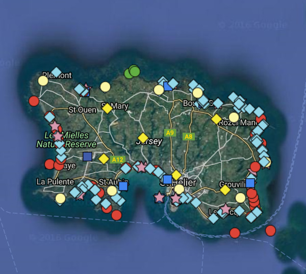
As part of a little project, I have been trying to map the positions of all 18/19th century British fortifications. That is to say all of the forts, redoubts and batteries. On my initial count, these number some 130-plus separate positions, which range from full fortresses like Fort Regent to an individual battery, which would often include ancillary buildings like a guard house and magazine for gunpowder. To this, one must also add all the signal stations (10), barracks (12), arsenals (6), drill halls for most parishes and the 18 military roads built on the orders of the Island’s Lieutenant Governor, General Don, which criss-cross the Island and now form the backbone of Jersey’s main road network.
Whilst most of the Jersey Round and Martello Towers, the Castles and larger forts very much still exist, the gun batteries have just about all disappeared, or where there are remains, they are not normally recognised by the passer-by. All but one of the signal stations have gone (the one at Fort Regent remains and will be the subject of a future blog), as have the drill halls and most of the barracks. Most of the arsenals still exist, but they are generally hidden under later modifications and their original purpose forgotten by many.
But when you plot all of these fortifications on a map, the reaction is likely to be “Wow! The Island is bristling with guns. It is no wonder that Napoleon never risked invading!”
As I said, this is an ongoing project. I know that the positions of some of the batteries are not precisely right as their locations have been lost over time. But perhaps someone needs to remedy this and now go and have a look and see what archaeological remains can be found?
Moreover, it is time to recognise that Jersey’s military history and heritage are not a number of isolated periods or individual buildings. Jersey Military history is the whole lot, from prehistoric times, through the medieval period and right up to the 20th century. It is a continuous evolution of defensive military strategy which affected everyday life here for centuries.
Jersey military history is, in many ways, Jersey’s history – or at least for the last 800 years or so from when it was thrust onto the frontline between warring England and France!
And so I leave it to the reader to decide – whose defences reached the higher pinnacle? The British or the Germans? Or perhaps it is an honourable draw based on their respective times?
On the map, the key is:
Forts – Lilac star; Towers – Red circle; Batteries – Light blue diamond; Barracks – Blue square; Separate Guard Houses – Green circle; Arsenals – yellow diamond; Signal stations – Light yellow circle
Please let me know by emailing me via the Contact page if you would like a link to the scalable version of the map which will reveal the positions hidden under others, as well as the names of all of them.
Note: It is interesting that in June 1940, immediately before the Occupation, the Germans, who had not been told that the British Government had demilitarised the Channel Islands and left them defenceless, had been fooled by aerial reconnaissance into believing that Jersey’s old and obsolete fortifications were still in use and that they would have to be overcome by any German invasion. Such was the still impressive aura that these defences had, as well as the presence of dozens of potato or tomato lorries waiting to export their produce at the harbours and mistaken for troop lorries, that the German Luftwaffe bombed and strafed the Islands before sending in occupation troops!
Marc Yates is the owner of History Alive! & Jersey Military Tours